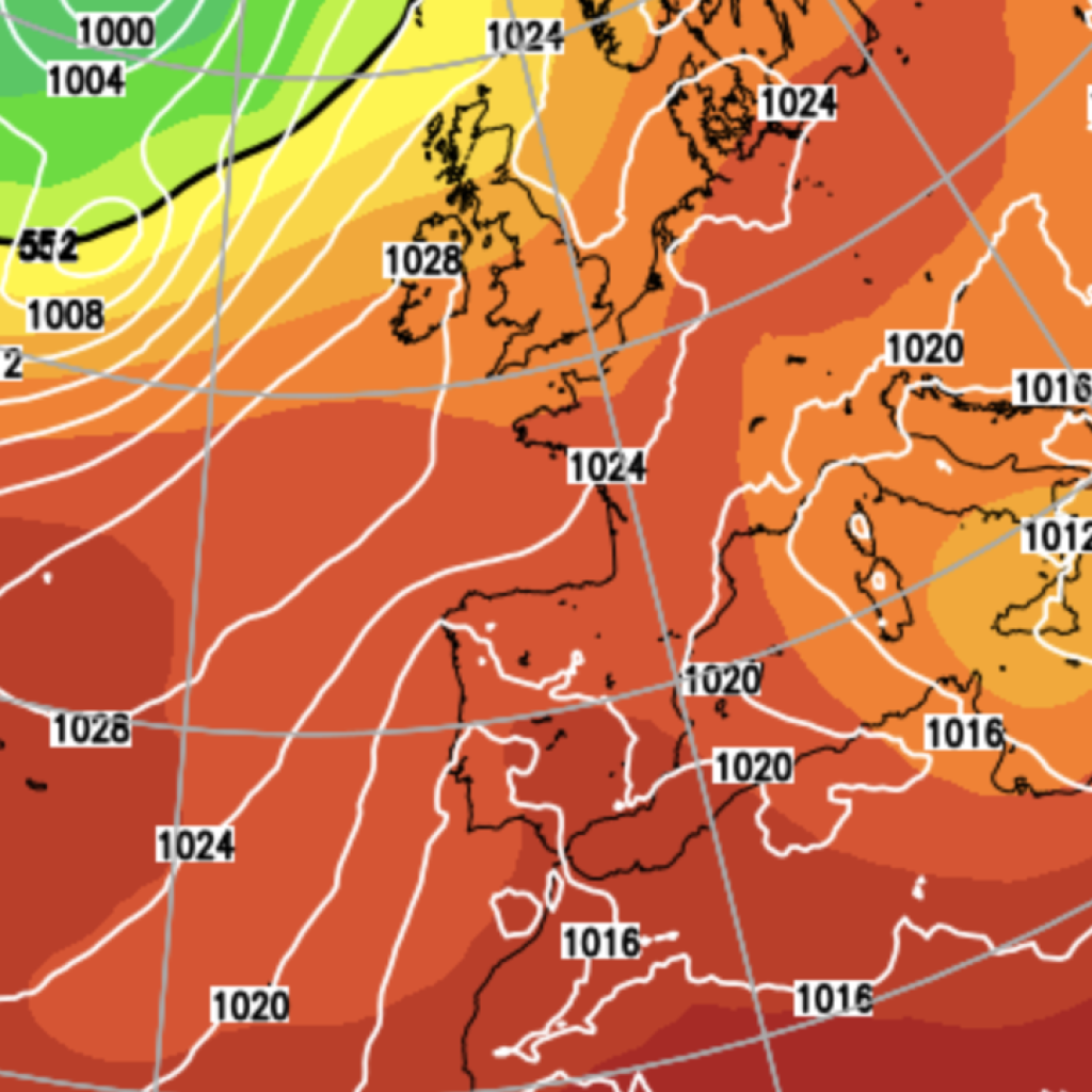
A rapidly deepening area of low pressure west of Ireland is set to bring gales, rough seas and heavy rain to the British Isles, while drawing an exceptionally warm and humid air northwards.
Two low-pressure systems are expected to merge west of Ireland over the next 24 hours, with one system originating in the subtropical North Atlantic.
The resulting conditions are forecast to progress rapidly in what is known as explosive cyclogenesis, or a “weather bomb”.
This incoming weather bomb could reach its deepest point by late morning today, although the core of the storm is expected to remain offshore.
Ireland and western coastal areas of the UK are likely to experience gale-force winds, reaching Force 8 or strong Force 9 in exposed locations – speeds of 39 to 54mph.
Seas will become very rough, with large waves potentially overtopping coastal defences and causing flooding, particularly as the storm coincides with spring tides.
The strongest winds, potentially exceeding 80mph, are expected to remain offshore to the west of Ireland.
At the same time, conditions will draw a strong southerly to south-easterly airflow across the west coast of Britain, transporting unusually warm and humid air northwards.
Temperatures are forecast to reach the mid-twenties across southern England as the week progresses, while overnight temperatures will also remain unusually high, with some southern and eastern parts of the UK potentially staying around 19C.
The warmth will come with a risk of severe rainfall and thunderstorms further south.
Very high sea-surface temperatures in the Mediterranean could provide additional moisture, increasing the potential for intense rainfall through to Thursday.
A long cold front linked to the Atlantic low sweeps eastwards overnight, bringing rain across the UK.
LATEST DEVELOPMENTS:
Greggs to close FOUR manufacturing plants with 740 jobs set to be lostMan charged after allegedly stabbing police officer in LondonBritain finally backs down on ‘crackpot madcap scheme’ to dim the Sun
Cooler and fresher air will follow the front, with showers potentially becoming heavy and thundery, particularly around southern and western coastal areas of the UK.
Conditions should gradually settle across southern England from Thursday as high pressure builds. Ireland and northern England, however, are likely to remain more exposed to Atlantic weather systems, with further rain and showers possible.
By the weekend, high pressure is expected to strengthen across the south and extend northwards, potentially restricting persistent rain mainly to northern Scotland.
Temperatures across much of western Europe could remain around 3C to 7C above the seasonal average.
Met Office Chief Forecaster Matthew Lehnert said: “A deep area of low pressure far into the Atlantic is the primary driver behind the UK’s weather over the next few days.
“Its first influence will help pull some warmer air over much of the country, notably warm for the time of year. A warm night will follow across southern and eastern areas, with minimum temperatures of 19C in places.”
The latest spell comes against a backdrop of an exceptionally warm 2026. The Central England Temperature record was 2.6C above its long-term average as of last Saturday, with every month so far this year recording a mean temperature above its historical average.
The Met Office’s latest three-month outlook for October to December also points to an increased likelihood of milder-than-average conditions continuing into autumn and early winter.
Our Standards:
The GB News Editorial Charter